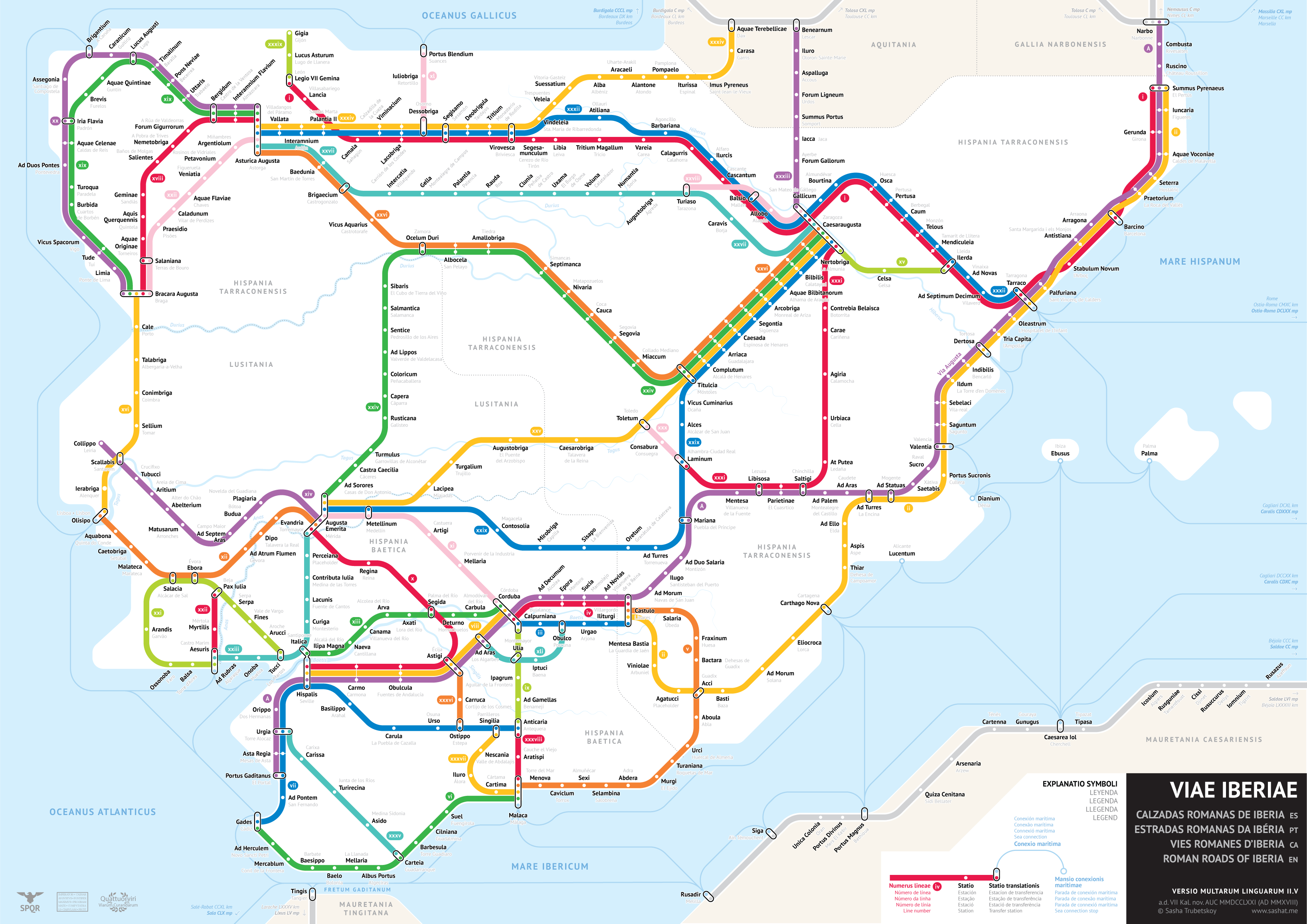
Roman Roads of Iberia
27 May 2018

Notes:
This map was a blast to make. I chose to follow the Antonine Itinerary more strictly, which meant that I had to deal with many parallel lines. This forced me to go out of my comfort zone with a new design, but I think it looks good in the end.
“Line number” generally corresponds to the iter number in the Antonine Itinerary. The following line numbers do not match the Antonine Itinerary: ix, xiii, xv, and any number above xxxiv. The reason for this is that a couple of Antonine routes were ambiguous and not easily placed on a map, while a few important routes were missing for which there is archaeological evidence. I excluded those “broken” Antonine routes and included important missing ones, assigning them numbers.
Once again Pelagios and Stanford Orbis were a huge help. Big thank you to Pau De Soto for providing me with shapefile data on the Antonine Itinerary in Hispania and Lusitania, which I was able to use to help me sketch out the map.
Fixes
Versio II.III:
- Minor alignments/adjustments
- Added modern place names for Brevis and Aquae Quintinae
- Fixed loose label for Brigantium (A Coruña)
- Changed modern name for Sebelaci from Villarreal (Castilian spelling) to Vila-Real (Catalan spelling)
- Fixed modern location of Ildum (La Torre d’en Doménec)
- Replaced Victoriacum with Suessatium
Versio II.IV:
- Renamed Palantia on Line XXIV to “Palantia II” to prevent confusion with the station on line XXVII
- Moved Brigantium-Portus Blendium sea connection slightly down so that it maintains the proper margin from the border
- Renamed “Emerita Augusta” to “Augusta Emerita”, since the latter name was more commonly used
- Titulcia is most likely present-day Móstoles, according to the most recent scholarship. I have changed the modern name accordingly.
Versio II.V:
- Added modern place names for cities on line xxxv (I guess the file didn’t save the last time I did it…)